This article is outdated !
A newer version of the app with a completely redesigned interface and updated features is now available. Please read our latest post here: Dump1090 – Android – ebcTech.eu
Frequently Asked Questions:: All about Android Dump1090 ADS-B App
What is it ?
Dump1090 turns your Android phone, tablet, or TV box into an ADS-B receiver and displays nearby aircraft on a map in real time.
It is designed for portable, on-the-go use — not as a replacement for permanent Raspberry Pi–style receivers.
See what hardware you need
Is there a Tutorial ?
Yes — step-by-step guide here: Tutorial
What Hardware do I Need?
See the shopping guide → shopping list
Which SDR devices are supported?
Device support depends on the Driver App RTL-SDR Driver by Martin Marinov.
Supported hardware includes:
- RTL2832U-based USB dongles (R820T, R820T2)
- HackRF devices: HackRF One, Rad1o, HackRF Jawbreaker (not fully tested)
Is it free ?
There is a message limit for free users. When the limit is reached, the app pauses — tap the play button to restart.
Premium removes the limit — one-time purchase, no subscription, usable on all devices linked to your Google Play account.
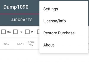
To activate a purchase you already made:
- Open the Aircraft tab
- Tap the three-dot menu (top right)
- Select Restore Purchase
Can I feed data to FR24 / Radarbox / etc.?
The app was not designed as a permanent feeder. RTL-SDR sticks drain the battery quickly (a USB-C hub can power the stick externally).
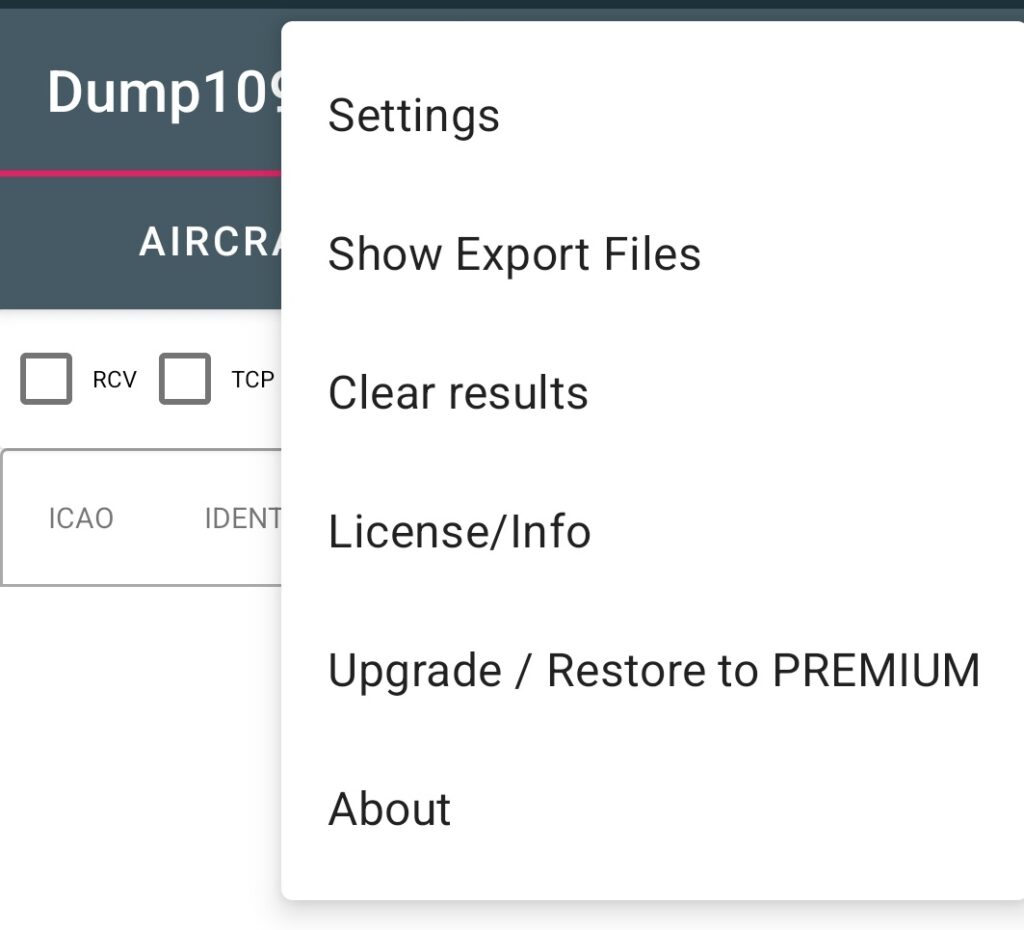
A TCP export server is available — go to Settings on the Aircraft tab (three-dot menu). Other apps such as Virtual Radar Server can connect to it.
Direct feeding to FR24, Radarbox, and similar networks is not currently supported — their feeder software is Linux/Raspberry Pi only with no public API for direct upload.
read more in detail here Dump1090 Export
Aircraft appear in the list but not on the map
Aircraft without position data (no LAT/LON in the ADS-B message) cannot be shown on the map.
Fix: The app needs your device location to calculate distances and filter data.
- Accept the location permission dialog on first launch.
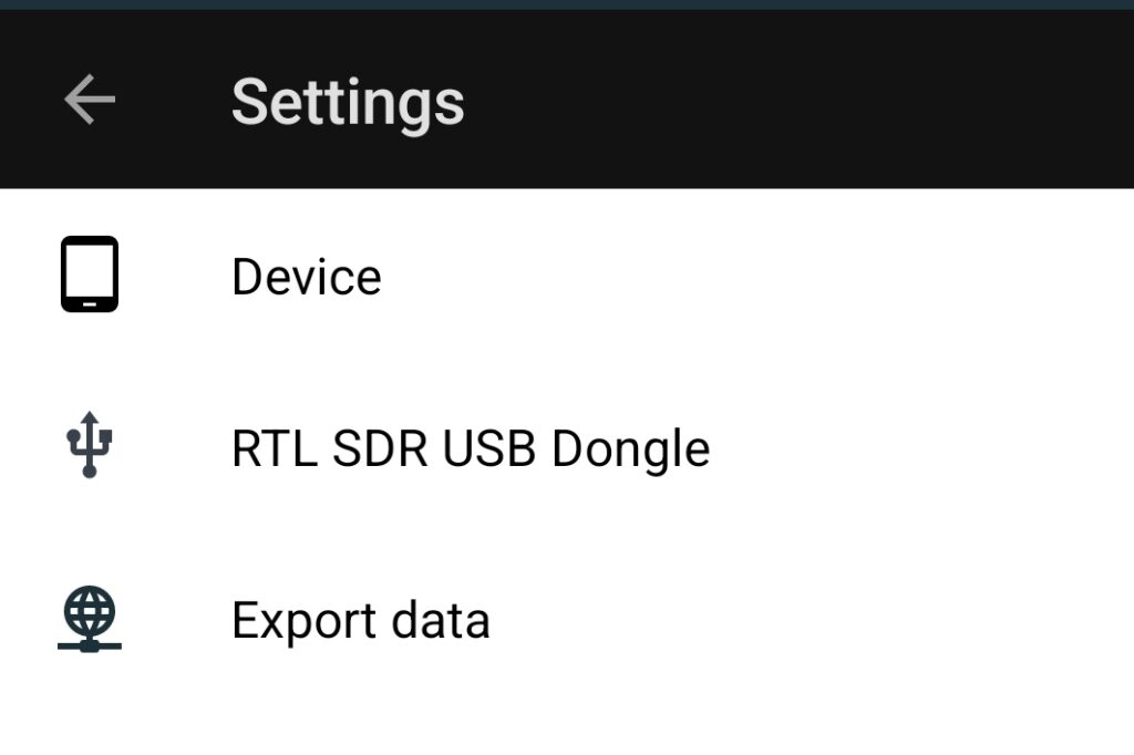
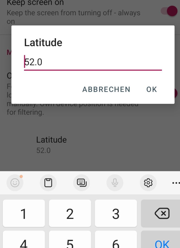
- If aircraft still don’t appear: stop the app → Settings → Device → Mock Device Location → Enable “Override device location” → enter your coordinates manually.
This is especially useful on older devices or some brands that restrict background location access.
Error message when pressing Play
I get this or similar error message when i try to start with the pink play button.
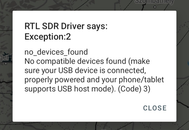
In most cases this resolves it:
- Unplug the USB OTG cable from your Android device.
- Reconnect the cable. (Remove the OTG cable itself, not just the dongle.)
The app shows – wrong argument …
Some RTL-SDR dongles cannot tune to 1090 MHz. Use an R820T or R820T2 stick.
See also Dump1090 Shopping Guide
| Tuner | Frequency range |
| Elonics E4000 | 52 – 2200 MHz with a gap from 1100 MHz to 1250 MHz (varies) |
| Rafael Micro R820T | 24 – 1766 MHz |
| Rafael Micro R828D | 24 – 1766 MHz |
| Fitipower FC0013 | 22 – 1100 MHz (FC0013B/C, FC0013G has a separate L-band input, which is unconnected on most sticks) |
| Fitipower FC0012 | 22 – 948.6 MHz |
| FCI FC2580 | 146 – 308 MHz and 438 – 924 MHz (gap in between) |
Application stops working after a while
If you see:
Possible inconsistency: No data received rom RTL SDR. Maybe press pink Play/Stop button again
This is usually caused by aggressive battery/power management — especially common on Huawei devices.
Fix: Add both the RTL-SDR Driver and Dump1090 apps to your battery optimisation whitelist (set to “Not optimised”).
Further reading: Dump1090 Export · Don’t Kill My App
Can you add a feature
Sure why note. Write me a mail info@ebctech.eu
I’ll put it in on my TO DO list
Can I use DUMP1090 Android in my country ?
The app has no technical region restrictions. It is your responsibility to comply with local regulations regarding radio reception equipment.
DUMP1090 does not have any technical limitations regarding location of usage and can operate everywhere where it is legally allowed to. The DUMP1090 development team will not be held responsible for any legal issues that might be caused by usage or possession of the app. It is your responsibility to comply with your local law before using the apps as clearly stated in the Terms and Conditions you receive bundled with the app.
DO NOT rely upon DUMP1090 for safety of life or property. DO NOT use these app for navigation purpose.
Disclaimer
THIS SOFTWARE IS PROVIDED “AS IS”, WITHOUT WARRANTY OF ANY KIND, EXPRESS OR IMPLIED, INCLUDING BUT NOT LIMITED TO THE WARRANTIES OF MERCHANTABILITY AND FITNESS FOR A PARTICULAR PURPOSE.
IN NO EVENT SHALL THE AUTHORS OR COPYRIGHT HOLDERS BE LIABLE FOR ANY CLAIM, DAMAGES OR OTHER LIABILITY, WHETHER IN CONTRACT, TORT OR OTHERWISE, ARISING FROM, OUT OF OR IN CONNECTION WITH THE SOFTWARE OR THE USE OR OTHER DEALINGS IN THE SOFTWARE.
This application is not certified for aviation use.
DO NOT rely on this software for safety of life or property.
DO NOT use this application for navigation, air traffic control, collision avoidance, or any safety-critical purposes.
The displayed aircraft data may be inaccurate, delayed, or incomplete. The accuracy and availability of received signals cannot be guaranteed.
This application processes radio signals (ADS-B at 1090 MHz) using an RTL-SDR compatible device.
Reception and decoding of radio signals may be restricted or regulated in some jurisdictions.
You are solely responsible for complying with all applicable local laws and regulations.
The developers assume no responsibility for any legal or regulatory violations resulting from the use of this application.
Credits / Open Source
This app includes components licensed under the GNU General Public License v2 (GPLv2). In accordance with GPLv2, the corresponding source code is publicly available at:
🔗 github.com/ebc81/dump1090andro-gpl-sources
A full list of all open-source libraries used in this app is available in-app under Menu → Licences.
You may also request the source by email at info@ebctech.eu (valid for 3 years from your download date).
Legal attribution
Android, Google Play and the Google Play logo are trademarks of Google LLC. All other product names, logos, and brands are property of their respective owners.
No aircraft ID on map view? App works well otherwise but portable stand-alone use severely limited when targets cannot be identified on the map.
A aircraft will only appear on the map if it has a longitude / Latitude information.
So please check if you see in the aircraft tab list – items with a LAT and LONG value.
Is Location Service enabled on your device ?
https://support.google.com/accounts/answer/3467281
Hello, I have the same problem, I’m getting plane info like ALT , IDENT, SQUAWK, etc but no LAT or LONG. my GPS is on and working, but no planes show up on map. I tried Avare and some planes showed up on map with tracks , until free trial ran out lol
I use an android tv box. At first I had a similar problem as you. Then I figured, my box might have limited location capability. I then used an app called “Fake GPS” from Playstore, set it as mock location source. Then all aircraft appeared in the map.
Hi
As i wrote you in a sperate email which you already answered but for publicity here the current status to this issue:
1.) What Android version and which brand is your device ?
2.) When you switch to the MAP tab.
Do you see the blue circle ?, which should represent your position ?
See also screenshot attached.
3.) At first time start the app need to have the location permission from the user. Maybe you could completely uninstall the app an reinstall it.
ANSWERE
I’m using a rather unique setup. It’s a Raspberry Pi 4b+ that has Lineage OS (android 12) I have a ublox GPS dongle which works with other apps but I don’t believe it worked with yours. I’m pretty sure I gave location permissions, etc. I will try to uninstall the app and try again today and give you an update.
I really hope you can enable manual gain settings. I live near an active runway. I assume the gain setting is set to MAX. Hence, any close aircraft tends to disappear since it’s signal overwhelms the receiver.
I really hope you can enable manual gain settings. I live near an active runway. I assume the gain setting is set to MAX. Hence, any close aircraft tends to disappear since it’s signal overwhelms the receiver.
Good idea. Will implement this in a next update. But could take a weile.
Good idea. Will implement this in a next update. But could take some weeks…
Hi!
Is it possible to connect to some kind of offline database, converting the HEX to the registration/type/operator ? That would be awesome ?
This is already done. I use basically the same data https://opensky-network.org/aircraft-database.
These database is some kind of pu lic source. It is mentioned in the license information of myapp.
But I have to copy the public csv files manually from opensky and manually import it to my server.
On the map tab you see then additional Infos like operator linked to the hex number.
If you have airplanes without this info enter it on the opensky homepage. I will merge the data every month.
And i forgot – for this you need internet access
I was thinking of offline database in the beginning -but database size is today more than 80 mb.
OK, clear.
Too bad though, as I was hoping to have the option to use this offline somehow (areas with bad connection, expensive roaming, big-brother is watching you countries ? )
Thanks for the answer though!